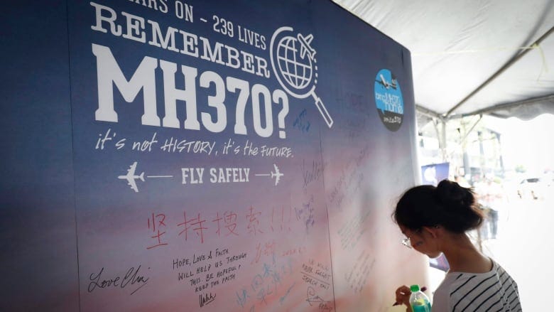
Malaysian Flight 370
Malaysian Flight 370
An aviation mystery

Lately I’ve been obsessed with watching shows on YouTube about aviation accidents and aviation mysteries. There is a really smart independent producer of videos, a British fellow whose channel is called Green Dot Aviation. His videos are very technical, usually first explaining to the viewer the type of plane used in the accident. Its capabilities, its advantages over older model planes, and its disadvantages. Many of the videos I watch on Green Dot cover accidents that occurred on Boeing 737s, Boeing 747’s, and Boeing 777s (Malaysia Airlines Flight 370). Another very popular model is the Airbus 330, which was the Air France Flight 447 plane that, almost inexplicably fell out on the sky on a routine flight from Rio de Janeiro on June 1 2009. Green Dot Aviation covers the entirety of these doomed flights, all while playing the black box recorder at the appropriate times, so you feel almost as though you are in the cockpit with those pilots. Another show I really enjoy is a Canadian-produced half-hour program called Mayday: Air Disaster, a show that is still producing episodes as of 2024.
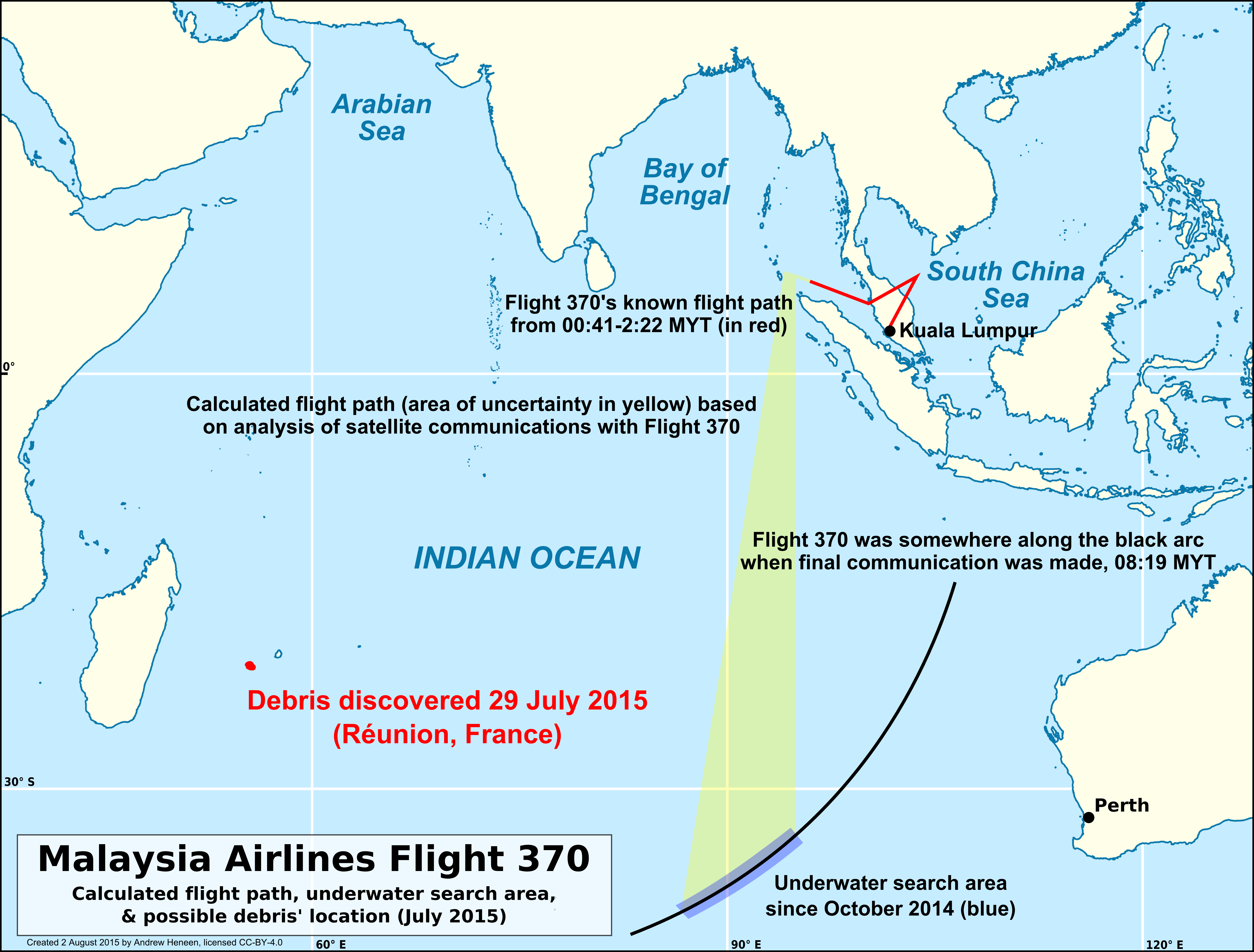
Air France Flight 447 was the reigning king of mysterious aviation accidents involving commercial passenger flights until March 8 2014, when Malaysia Airlines Flight 370, yet another routine flight from Kuala Lumpur to Beijing, completely vanished. The reason Flight 370 immediately overtook Flight 447 in terms of sheer mysteriousness is the fact that, unlike Air France 447, Malaysian 370 deviated from its flight path at a very suspicious point in its journey, mere moments after saying goodnight to Air Traffic Control in Kuala Lumpur and moments before entering Vietnamese airspace over the South China Sea, where lead pilot Captain Zaharie should have immediately made contact with Air Traffic Control in Ho Chi Minh City (formerly known as Saigon). This he did not do. It was at this point in the flight, at 1:22 Malaysia Time, that the plane, which had been consistently heading northbound to Beijing, banked left and turned around over the South China Sea. It then proceeded to fly back toward Malaysia, but at the very northernmost point of the country. The plane had been skirting the boundary between Malaysian airspace and Vietnamese airspace, and it continued this suspicious mode of travel as it began to proceed in a southwesterly direction, back toward Malaysia, where it straddled the border between Thailand and Malaysia, like someone threading a needle, banking in and out of two separate country’s airspaces. The only reason investigators could come up with for these blatantly evasive maneuvers is that the pilot of Malaysian 370 was doing his damnedest to avoid detection. About a month earlier, he had used his home flight simulator to make an absolutely baffling flight, one that initially headed north before cutting back toward Malaysia after exiting Malaysian airspace. In this simulated flight, the pilot reached Penang, the city he grew up in on the southwest coast of Malaysia, before turning northwest in order to avoid Indonesian airspace. He continued northwest over the Bay of Bengal until he was out of reach of Indonesian airspace or military radar, then executed his final turn due south (in real life, this turn occurred at 2:22AM), and the plane then flew south without deviating until running out of fuel somewhere in the deepest southeast reaches of the Indian Ocean. The fact that investigators found this simulation on Captain Zaharie’s flight simulator was very suspicious, and made it seem as if he wanted to make the plane vanish from the face of the Earth. The location where the plane would have crash landed into the sea due to running out of fuel was so remote, it took the Australian Navy four days just to get there. Search efforts had previously been undertaken in the South China Sea, where Malaysian 370 made its last communication.
In the ensuing years, pieces of the plane began to wash up on La Reunion, a French island in the middle of the Indian Ocean, as well as on the eastern beaches of African coastal nations, and the eastern beaches of Madagascar. As more and more pieces of Flight 370 were found not in the South China Sea, but on eastern beaches of the Indian Ocean, it became more and more likely that Captain Zaharie deliberately flew his plane to one of the most remote places on the planet. His motivation has never been established. To give you a visual indication of where his plane probably ended up, here is an image:
One talking point that arose was this: Just what were the passengers thinking and doing as a five hour flight turned into an eight hour one, with no indication of land below, just the white caps of waves in the Indian Ocean, or perhaps the Southern Ocean? Green Dot Aviation believes that the passengers were either dead, unconscious, or hypoxic due to the pilot depressurizing the cabin. Green Dot Aviation further believes that the pilot asked his co-pilot First Officer Fariq Abdul Hamid to leave the cockpit for some erroneous reason, and then locked him out, dooming Hamid to the same fate as the passengers. Zaharie would have had his own oxygen tank, which provided 4 hours of oxygen, as well as Hamid’s tank, which provided another 4 hours, giving him more than enough oxygen to fly the plane to the most remote location possible. Even if the oxygen tanks were not filled, once Zaharie made his final southbound turn, all he had to do was put the autopilot on, so if he ran out of oxygen before the plane ran out of fuel, the plane would still fly in the direction Zaharie had input until it ran out of fuel and fell out of the sky.
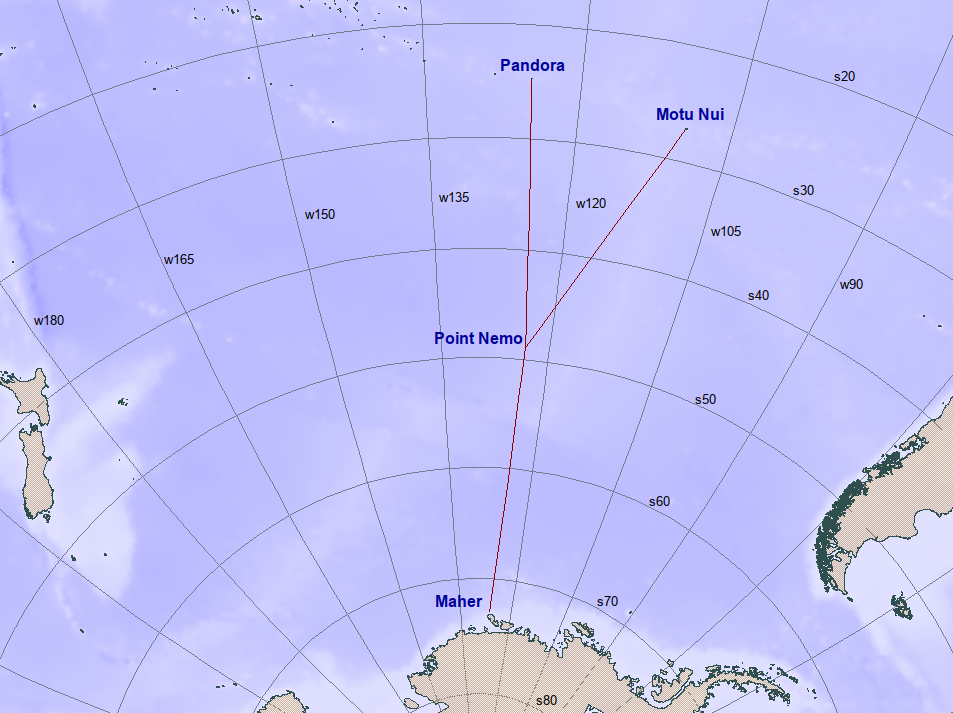
That’s a chilling thought, somehow. It’s scary enough to imagine a plane full of dead or hypoxic passengers flying to as remote a location as one can be (save for Point Nemo, which is a point in the Pacific where, if one were to be dropped there, you would be as far away as possible from the nearest landmass on Earth. According to Wikipedia, “The area is so remote that—as with any location more than 400 kilometres (250 mi) from an inhabited area—sometimes the closest human beings are astronauts aboard the International Space Station when it passes overhead.”
The one piece of actual evidence that Zaharie did in fact take this route is not the flight on his home simulator. That, although highly incriminating to my mind, is still circumstantial. Zaharie did not take into account the fact that the British company Inmarsat had both a ground station and a satellite that made automatic communications with the aircraft as it flew southbound over the Indian Ocean. No human was trying to get ahold of Captain Zaharie via Inmarsat. It was merely an in-built component of the Inmarsat ground station and satellite to “link up” to data units that are aboard every modern commercial jetliner. The airplane was sending automated requests to “link up” to the Inmarsat satellite. While this could not provide the aircraft’s exact location, it could provide a series of arcs along which the plane could have been travelling. These automatic pings are referred to as “handshakes” and provided the first incontrovertible evidence that Malaysian 370 was still flying as late as 08:19:37 Malaysian Time. That was the final “handshake” between the aircraft and the satellite, but the many handshakes provided a series of possible locations for the aircraft. This final “handshake” message at 08:19:37 is the last piece of data received from Flight 370. The aircraft did not respond to a status request from Inmarsat at 09:15, which means that it crashed sometime after 8:19 but before 9:15. Here are some of the arcs, which were created by measuring the aircraft’s distance from the satellite:
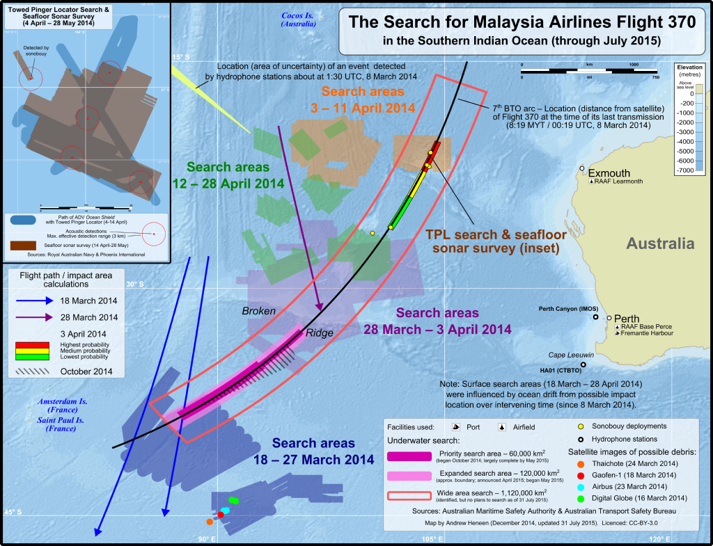
The world’s oceans are all connected, and are better thought of as divisions than discrete oceans unto themselves. Having said that, the Southern Ocean is infamous for its massive swells, rapid changes in weather, and generally miserable conditions. That the Australian authorities took on the responsibility of attempting to find the wreckage of Malaysian 370 across an absolutely massive search area is a testament to the seriousness and rectitude with which they take their place as members of the global community.
It being 2024, and at least 300 years since the entire globe was mapped, we tend to think that the ocean floors are mapped too. This is not the case at all. Just one-fifth of the world’s oceans are mapped, with a disproportionate amount of that mapping being done in the North Atlantic, due to the enduring popularity of the Titanic, easily the most famous shipwreck of all time. The Mid-Atlantic Ridge has also greatly helped the mapping of the Atlantic, because in the middle of that ocean is the biggest and longest mountain range on the planet, making the Atlantic much easier to map than the Pacific or Indian Oceans, seeing as its depth climbs and climbs as boats get closer to the middle of the ocean. It follows that it is simply easier to measure a shallow ocean. The average depth of the Pacific Ocean is 4,280 m, while the average depth of the Atlantic is 3,730 m. The Pacific is also host to the deepest oceanic trench on the planet, Mariana’s Trench, which is 1,554 miles long and 44 miles wide, or 120 times larger than the Grand Canyon. According to the National Oceanic and Atmospheric Administration, the trench is almost 5 times wider than it is deep.
So the cumulative effect of the Mid-Atlantic Ridge means that the Atlantic is the shallowest of the world’s major oceanic divisions. It’s not a huge difference, the average depth of the Atlantic being 3,730 m and the average depth of the Indian Ocean 3,741 metres, but the Indian Ocean has been far less traversed, studied, and mapped. The Atlantic has 20 major shipping lanes, while the Indian Ocean has just 5.
Once again, there seemed to be a concerted effort on part of the pilot to avoid detection of the plane by military radar by flying along the border of Malaysia and Thailand, crossing in and out of each country's airspaces. Although Air Traffic Control in Kuala Lumpur had no idea that Malaysia 370 had turned back, Malaysian military radar should have (and was later found to have had the capability to easily track the plane’s progress along the mountainous border of Malaysia and Thailand. The question then became, was anyone watching?) In my opinion, nobody was watching the radar that night. They had no reason to monitor a specific area of the Malaysian border, and one would have to think that if the Malaysian military had detected a plane weaving in and out of their airspace, they would have sent at LEAST a pair of military jets to investigate.
By “investigate” I do not mean that the Royal Malaysian Air Force would have simply caught up to Malaysia 370 and blown it out of the sky. They most likely would have intercepted the plane, with each fighter jet flying alongside opposite sides of the aircraft until they could have identified it. The Malaysian Air Force has 176 jets ready at a moments notice to be deployed. Some of these jets are ancient but many of them are F/A-18D twin-seat fighters which serve in both air defense and strike roles, serving alongside 18 Russian-built Sukhoi Su-30MKM Flanker-H jets. The Hornets were acquired in 1997 and have been upgraded over the past decade.
Therefore, because Malaysia had no shortage of jets with the ability to intercept Malaysia Flight 370 as it made its way southwest weaving in and out of its own and Thai airspace, it follows that nobody in the Malaysian military or Navy or Air Force was monitoring that particular section of Malaysia’s northern border between 1:22AM Malaysian Time on Match 8 2014 to exactly one hour later, at 2:22 when Flight 370 made its way northwest into the Bay of Bengal, out of range of Thai, Malaysian, and Indonesian radars.

As you can see, the lighter blue sections in the image above are sections of ocean floor that are mapped. Maybe not mapped to the precision and degree that the Atlantic is, but there seems to be an honest effort to map this ocean that covers 19% of the planet, a co-operative effort between nations and research organizations. One such organization, the Carnegie Endowment for International Peace has launched the most ambitious effort to map the Indian Ocean yet. The above image is from their website, and their mission statement is here:
For decades, the Indian Ocean region has been erroneously studied through the continental divisions of Africa, the Middle East, and South Asia. But to understand the true importance and strategic advantages of the region, it must be viewed as one continuous theater. The Carnegie Endowment for International Peace’s Indian Ocean Strategic Map does just that. Developed by Carnegie’s Indian Ocean Initiative, the map provides a coherent, continuous, and data-driven understanding of the players, security challenges, and other factors that shape the region. The first of its kind, it shows how the Indian Ocean’s economic, political, military, and geographic features interact to create a single geopolitical arena.
Clearly they’ve made inroads, but God look at all that yet-to-be-mapped water. Water that lies outside the oceanic borders of given nations is often given less attention because of the fact that it belongs to nobody. It would be difficult to convince India to map an entire ocean just because they share a name. Mapping ocean floors is costly mainly because the pressure would cause a human being to combust in a nanosecond. But as marine robotics become cheaper, more and more companies are sending unmanned vessels down to the depths where they are slowly, meter by meter, mile by mile, kilometre by kilometre, mapping the mysterious Hadal Zone and beyond. Places where species humans have never laid eyes on may thrive.
The aviation community is now certain that the wreckage of Malaysian Airlines Flight 370 lies somewhere on the ocean floor between Amsterdam Island and Australia. This is an area that contains no shipping lanes, and the fact that the first few weeks of searching were limited to the South China Sea (this was before someone at Inmarsat realized “woah…we’ve got is or seven handshakes with the most mysterious missing commercial jetliner in human history”), any debris that may have indicated where the plane went down would by this point have drifted hundreds of kilometres westward into the Indian Ocean, according to ocean current experts and computer simulations, hence the findings of bits of the plane beginning in mid-2015 on La Reunion, then Madagascar, then Mozambique, Tanzania, Somalia, and eastern beaches of the Seychelles.
Pieces of the Boeing 777 that made up Malaysian Flight 370 could not have drifted to these locations if, as some conspiracy theorists still believe, the plane went down in the South China Sea, a mere 38 minutes after takeoff.
The wreck of the Titanic wasn’t found until September 1, 1985. It sank on April 14-15 1912. But the Titanic remained in the popular cultural consciousness in a way that Malaysian Flight 370 has not yet seemed to, which is odd given the still gaping holes in the story.
All that knew Captain Zaharie vehemently deny that he was depressed or suicidal. He never showed any outward signs of malice or violent intent. The simulated flight Zaharie had run on his home flight simulator that took the exact same route Flight 370 did was just one of hundreds and hundreds of simulated flights Zaharie had flown on that simulator. Very few pilots love flying so much that they use a home flight simulator on their days off in order to take strange flight routes.
But we hear such protestations all the time. “If you knew him, you’d know he would never do something like this.” Okay. But most of the world didn’t know Zaharie personally, and if you take off the lens of friendship and/or fondness through which you view somebody, and look at the mountain of evidence that suggests someone intentionally flew Flight 370 to an extremely remote part of the planet, it’s difficult not to suspect the Captain.
I think the last piece of evidence that did it for me is the fact that Zaharie was from Penang, and he flew over that city when making his banked turn up through the Bay of Bengal, just outside of Malaysian and Indonesian airspace. He was taking one last look at the city he grew up in. Except it was dark outside and he wouldn’t have been able to see much.
That’s the problem with this whole damn case. Just when you think you’ve found the smoking gun, another fact comes along to cancel it out.
Facts that seem to point to Zaharie’s guilt:
1. He, or someone (not autopilot), turned the plane around moments after ceasing contact with Air Traffic Control at Kuala Lumpur.
2. The plane re-crossed the Malaysian landmass by straddling the border of Thailand and Malaysia. This suggests evasive maneuvers, or at least an attempt at flying undetected by radar of either nation.
3. The plane banked in such a way over Penang that it would give whoever was sitting in the pilot’s seat an unobstructed view of the city, even if it was nighttime, he would still have seen the lights below, the neon grid that a city appears to be from the sky, and if Zaharie was flying, he would have had a general idea of where above the city he was because he was born and grew up there.
4. The NTSB, Green Dot Aviation, the global aviation community, and the Transportation Safety Board of Canada all believe that this was a planned criminal event. According to the CBC, a Canadian aviation expert and former airplane crash investigator says he can state with "100 per cent certainty" that Malaysian Airlines Flight 370 was intentionally ditched in the ocean by one of the pilots in an act of murder-suicide. "This is a criminal event. It's not an accident," Larry Vance, a former investigator with the Transportation Safety Board of Canada, told CBC News in a phone interview. "This was planned and conducted, carried out by one individual who had control of the airplane via his job to have control of the airplane," Vance said. Either the pilot or co-pilot made the decision, "for whatever reason, to take it to a remote part of the ocean and make it disappear forever.”
5. The smoking gun, for many, would be the two pieces of wreckage from the flap system on the right wing of the airplane — the flaperon, and the section of flap that's next to it found on La Reunion in 2015: By examining the marks on the wreckage, they theorized that the flaps had been down when the airplane hit the water. This would mean that the plane had entered the water at a relatively low speed. "We would call that a controlled ditching into the water. And the only way that could happen is if somebody was flying the airplane. In particular, if somebody selected the flaps to be in the extended position."
6. Captain Zaharie apparently ordered two extra hours of fuel before the flight, although I cannot find a legitimate source for this claim.
Facts that seem to point to Zaharie’s innocence, or non-guilt:
If Zaharie did not, in fact, order two extra hours of fuel, there’s a whole hour that the plane was in the air when it shouldn’t have been. This was a routine flight. The pilots had flown it before and knew that the planned flight duration was 5 hours and 34 minutes, which would consume an estimated 37,200 kg (82,000 lb) of jet fuel. The aircraft carried 49,100 kilograms (108,200 lb) of fuel, including reserves, allowing an endurance of 7 hours and 31 minutes. But if the aircraft took off at 12:41 Malaysian time, how was it still in the air at 8:19 Malaysian time, which is when its last “handshake” with the Inmarsat satellite occurred? Where did this extra hour of fuel come from? This at least suggests that perhaps the Inmarsat data is/was flawed and maybe the plane did experience catastrophic failure over the South China Sea 38 minutes into its flight, which is when it ceased all communication with ground stations. Can a commercial jetliner on autopilot flying at 35 000 feet glide for a whole hour after total fuel exhaustion? Some aviation experts say an hour’s worth of gliding is possible, but only if done manually, meaning somebody would have had to have been at the controls, gliding the plane as far as it could possibly go, simply to create the most mysterious flight vanishing of all-time.
The Malaysian military belatedly informed the press and the relatives of the vanished passengers that they had indeed tracked the plane across Malaysia that night. If so, the only way they wouldn’t have sent fighter jets to intercept it is if the pilot, or someone else, communicated with the military radar station and explained its presence so far off its planned flight path.
Zaharie’s family and relatives vehemently deny his culpability and have stated he liked even the capability to carry out such a perplexing and evil plan. They say he was not that kind of person. His sister told CNN that he has become a “scapegoat.” She told CNN, “He’s been made a scapegoat from the beginning.” To CNN, she described the pilot as “very loving, wonderfully considerate and generous. A very, very generous younger brother – in fact most generous one of our family.”
It’s a mystery that may never be solved. I feel for the relatives of the passengers, many of whom are Chinese and were given the runaround for months by the Malaysian authorities. Had the true flight path of Flight 370 been made public immediately, perhaps Chinese authorities could have drawn on their deep pool of resources to send a fleet of ships and aircraft carriers and planes to the actual site of the plane crash.